Dear All,
I wanted to share with all of you one of my best flights ever!, I'm still high from last sunday and can't stop thinking on how good week end it was, since leaving Banchory on Saturday evening to de 4 hitch hike journey back to the car, plus drive up to scotland again.
I wanted to write somehting but my flying partner Scott, send his story to the Aberdeen Club forum first, and.....it's all there no need to add anithyng.
QTE
For once it seems I was in the right place at the right time on
Sunday.
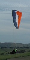
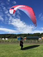
Given a grand total of 5 minutes flying time this year I was getting
desperate for a good flight, so Paolo, Jules and myself headed south
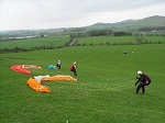
to Parlick- a south westerly site south of Lancaster.
As we arrived near the site we could see gliders in the air and all
got excited. Paolo got so excited he had to park last nights curry
behind a stone dyke before the short walk up the hill.
I wasn't expecting much, just a bit of soaring and maybe a short hop
over the back of the hill before the wind was expected to pick up too
much. Not so however. After 10 minutes of ridge soaring and getting
used to thermic conditions again I got a climb to take me to cloudbase
and start drifting over the back, chasing Jules and Brendan. Paolo
soon joined me over the back and showed some very good speed to try
and catch the leading Jules leaving me trying to keep up. According to
Paolo the reason I was struggling to keep up was my ears stick out too
much, there was me thinking he was racing ahead because his rounder
body is more streamlined.
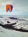
I got low a couple of times but the air was always bouyant and the
thermals were pretty predictable. We crossed the Pennines under cloud
streets and reached the flat lands where things seemed very easy. The
air over all the ploughed fields was going up and the clouds marked
textbook lift.
Brendan went down near the A1 while Paolo and I flew together slowing
down a bit as the lift became weaker as the day wore on. We saw Jules
in the distance go down, and felt a bit smug as we thermalled over
where he went down. If we had seen him I think we would have shouted
down some tips about thermalling. However bad things come to smart
arses!
In the distance I saw an airfield. As I hadn't been expecting a big
flight I didn't have a clue where we were, but I knew Paolo used to
fly around Newcastle so hoped he would know the airspace in the area.
Me: "Hey, Paolo, do you know where the airspace starts around here?"
Paolo: "Is that Eedinburg there?!"
Even though I was a bit lost I knew the city on the sea wasn't
Edinburgh and deemed the conversation not worth pursuing.
As I could make out the vague colouring of an easy jet plane in the
distance I thought landing was the only option, a painful decision to
make at 3000ft and still getting lift.
Thankfully we did, although i still think we skimmed airspace of Tyne
Tees approach. I haven't checked the tracklog against a map yet but am
not optimistic.
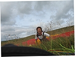
I landed with Paolo in a small village near Middlesborough after Paolo
showed a nice SAT- I think I impressed him with my big ears though.
We had a stroke of luck when a local paraglider pilot saw us walking
up the street of a village who gave us a lift to meet up with Jules
and the start of an epic retrieve getting back to Aberdeen at 3.30am.
With turnpoints Paolo and I flew 97km, 93km straight line.
UNQTE
It was not the duration or lenght of the flight that made it one of the best of my life, it was the quality of airtime, we really had a good time in up there, managing to share the last 2 hours together always side by side with Scott was just so good, it's this is all about, flying with people that feels the same you way do about life, you can't beat it.
Just wanted to add a BIG THANK YOU!!! to Mike from Eastcowton, near Darlington we landed on his village, and while going towards the local Pub to get a few dozens of pints to celebrate he saw us recognized the gliders and offered to help. He drove us a couple of miles to found Jules and afterwards dropped us in Scotch Corner to start hitch hiking. If it wasn't for him, we would probably be at the pub today... thank you Mike.
At last I managed to get a good flight in UK...oh man, it was worth every day of waiting.
See you in the air, and don't forget your friend up here, the house is small but the doors are always open to welcome you.
Paolo
A flight to remember.
Moderator: Club Moderators
-
John Wallis
- Seasoned
- Posts: 4072
- Joined: Tue Dec 20, 2005 7:17 pm
- Location: Northumberland
-
gary stenhouse
- Superstar
- Posts: 6288
- Joined: Tue Dec 20, 2005 7:21 pm
- Full Name: Gary Stenhouse
- Location: Company Director
you know why i do not listern to my predictions as i had texted several people about going to parlick for sunday and was told not a welcome place to none members.
sounded fantastic and a once a few years do opportunitys come to get flights like this in this country where multiple gaggles get away. the one thing that still would of mad a big differance is very good airspace devices as this would of allowd people to cross wind and avoid and extend there flights. ask ian
cheers gary
Totally agree with you Gary, If had a better vario/gps with Airspace would have been able to try a divertion.
That device it's high on my list of wanted toys, but can't affor one right now.
At the moment I think I will just load a series of waypoints on my Garmin 12, with names like ABD15 (Aberdeen 1500 feet)roughly drawing the No Go area, following that I can have that map with a 15km scale for the full size of screen and this will allow me to see the airspace with enough time to divert.
My second GPS, a Garming III Plus, will do the job of giving ground speed plus town names, etc.
I know this is not the most efficient way as the other instruments share vario and gps info to give you a whole lot more useful information but that will have t wait.
cheers
Paolo
I know it's going to label me an old dinosaur (so nothing new there) but you could always try using a map (like, one of those old fashioned low tec paper things)paolo wrote:Totally agree with you Gary, If had a better vario/gps with Airspace would have been able to try a divertion.
That device it's high on my list of wanted toys, but can't affor one right now.
At the moment I think I will just load a series of waypoints on my Garmin 12, with names like ABD15 (Aberdeen 1500 feet)roughly drawing the No Go area, following that I can have that map with a 15km scale for the full size of screen and this will allow me to see the airspace with enough time to divert.
My second GPS, a Garming III Plus, will do the job of giving ground speed plus town names, etc.
I know this is not the most efficient way as the other instruments share vario and gps info to give you a whole lot more useful information but that will have t wait.
cheers
Paolo
But seriously, surely a paper map is far better than a GPS at setting up diversions. If you have your GPS zoomed in far enough to pick up any sort of detail by the time the airspace comes up on your screen you're too close to alter your track to avoid it. A real map allows you to look further ahead. Anyone more experienced than me with GPS care to tell me I'm wrong and explain how you do it?
-
ron freeman
- Seasoned
- Posts: 3147
- Joined: Wed Dec 21, 2005 10:50 pm
- Full Name: Ron Freeman CFI
- Location: Cheviot hills, Northumberland
- Contact:
Dave
Dave, you are not old fashioned this is the correct way to plan an XC flight, plot your intended XC flight from your UPTO DATE AIR CHART then enter all the important information onto your GPS (if using one)
I fly with a Garmin 76c (colour screen) with all the UK Airspace, danger zones & Matz after checking my map I also check my gps by scaning my intended flight path for hot spots down wind, it only takes about ten minutes to sort out this invaluable information and you can then relax and enjoy the flight so much more.
In flight depending on the scale (map) that you set you can see airspace in plenty of time as to avoid it.
The CAA are looking for evidence all the time for airspace infringements so beware !
Maximise your time & dosh do both Hanggliding & Paragliding ")
yep, you both are right.
Paper airchart, forward preparation, the way to do it.
In fact I had an airchart with me, on my flyingdeck, but I am not good at reading it in flight yet, actually this is the second time I use it on a cross country, but probably the lack of flying over the winter made things a bit worse.
Personally I prefer the GPS, and what I want to try now, is to "draw" the airspace, with waypoints.
Then if you have a screen of let's say 1x2 inches, and you set up the bottom of your screen be equal of let's say 10km on the ground, then you do see the airspace coming and can divert accordingly.
Thanks for your advice. See you in the air.

.
When you travel so far it ain't so easy to be certain about navigation when in unfamiliar territory - I had some similar issues that cut the flight short too - with GPS and with map (OUT OF DATE - DOH).
Paolo - nothing takes the flight away does it
How the ankle doing? See you above the highlands soon!
Paolo - nothing takes the flight away does it
How the ankle doing? See you above the highlands soon!
-
Mike Brown
- Regular
- Posts: 584
- Joined: Wed Dec 21, 2005 10:00 am
-
colin keightley
- BHPA Club Coach

- Posts: 2483
- Joined: Fri Oct 12, 2007 5:22 pm
- Full Name: Colin Keightley
- Location: Stockton
- Contact:
Looking at the pennine soaring club website am I right in beleiving Paolo and chums have set a new PG record for Parlick http://www.penninesoaringclub.org.uk/pe ... arlick.htm
If Acro was easy they'd call it Cross Country
07824 554735
Livetrack24: Colinkeightley
07824 554735
Livetrack24: Colinkeightley