Dear all here are the way points for the next chance we get to hold the club comp. The start and finish is High Cap the first turn point is the road up to Great Dunn Fell the second is the radar masts and the third is High Cap. Down Load them and have a bit play.
http://fozz.dyndns-ip.com/myTrack/task/ ... 1379961218
JW
Way Points for club comp revised
Moderator: Club Moderators
-
John Wallis
- Seasoned
- Posts: 4072
- Joined: Tue Dec 20, 2005 7:17 pm
- Location: Northumberland
-
gary stenhouse
- Superstar
- Posts: 6288
- Joined: Tue Dec 20, 2005 7:21 pm
- Full Name: Gary Stenhouse
- Location: Company Director
after doing this run a few times and wind often being a problem I think the sheep pens is a safer turnpoint.
once you start going behind the forward ridge the wind can pick up massively so crossing the gap and getting to the actual sheep pens is better for low air time experienced.
though as I am righting this I think a good idea to make it more balanced is experienced pilots 200m radius turnpoints low airtime less experienced 1000m radius.
all will be fun and how much will you trust your gps
cheers gary
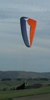
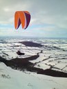
As a point of interest you can see from, Chris Fosters map of the proposed next task from X-Fell witch John Wallis has put together, The River south Tyne and the River Tees rise from the same Bog? 
Everyone who lives dies, yet not everyone who dies, has lived. We take these risks not to escape life, but to prevent life from escaping us ...

Problem is not all low airtime pilots will have a gps and are probably better off concentrating on their flying rather than bringing a new parameter into the equation. People will make better and safer decisions about their flying looking around them using their judgement rather than looking at numbers on a screen on their flight deck.
Could you work out;
500m to goal,
1500ftasl
Guess the ground elevation,
Know the polar curve of you glider
Have an accurate wind speed and direction, be able to triangulate your course direction,
Take into account undulating ground between you and goal
Set your course and apply the correct amount of speed bar.?
No,,,,,and neither can the instrument,,,,even when it says it can.
See you out there!!!!!
Surf crazed and dazed
Livetrack24 Nezzy01
Surf crazed and dazed
Livetrack24 Nezzy01
-
John Wallis
- Seasoned
- Posts: 4072
- Joined: Tue Dec 20, 2005 7:17 pm
- Location: Northumberland
Gary I'm surprised that you think that turn point is harder than the sheep pens? I've done the sheep pens many the time and I would always top up my height on the ridge above them where the turn point is situated ie where the road comes up Great Dun Fell then turns left and goes through the gate. I would have thought this would be much easier for pilots I've seen many go down actually going for the sheep pen turn point so at least this way they are actually soaring the ridge with the turn point on which is easier??
Brian
Those of us who want to try and get the best from our instruments using the turn point menu should make best use of it. If pilots don't want to use them just submit the ICG file as per normal and that will do. In fact if there's pilots who don't want to even do that fly the task judge for yourself if you're over the turn point and your word will be good enough. The only requirement is you will need a take off and landing time.
Lets not get too heavy about this I want it to be fun and enjoyable gone are the days when there would be fist fights for points
Flying for fun")
Brian
Those of us who want to try and get the best from our instruments using the turn point menu should make best use of it. If pilots don't want to use them just submit the ICG file as per normal and that will do. In fact if there's pilots who don't want to even do that fly the task judge for yourself if you're over the turn point and your word will be good enough. The only requirement is you will need a take off and landing time.
Lets not get too heavy about this I want it to be fun and enjoyable gone are the days when there would be fist fights for points
Flying for fun
-
gary stenhouse
- Superstar
- Posts: 6288
- Joined: Tue Dec 20, 2005 7:21 pm
- Full Name: Gary Stenhouse
- Location: Company Director
-
John Wallis
- Seasoned
- Posts: 4072
- Joined: Tue Dec 20, 2005 7:17 pm
- Location: Northumberland
-
ron freeman
- Seasoned
- Posts: 3147
- Joined: Wed Dec 21, 2005 10:50 pm
- Full Name: Ron Freeman CFI
- Location: Cheviot hills, Northumberland
Vario
Brian, if your vario can't do at least half of what you say.. its time to change your vario  but.. it do agree with low airtime pilots should not be using there gps for a club competition (turn points ect..) they have more than enough to think about and do !
Maximise your time & dosh do both Hanggliding & Paragliding
-
gary stenhouse
- Superstar
- Posts: 6288
- Joined: Tue Dec 20, 2005 7:21 pm
- Full Name: Gary Stenhouse
- Location: Company Director
I think the beauty with the gps is that we nearly all have the same one.
so it will make it easy for us to help one another set up the devices and have a go.
I am happy with whatever but you have got to remember these trophies used to be fearsly fought after and not just for a tootle about.
the first year I cam to cross fell 2005 I did not have a clue and nor did about another 10 others up the hill so we just enjoyed the day.
at the end of the day if your having enough trouble just reading your device and struggling to fly then it is unlikely to make you winn the comp.
take the lakes charrity classic by just missing a turnpoint as I did not set up correctly cost me dearly and there was lots of others done the same.
however a novice who does his homework on there gps they stand a good chance of sneaking a winn
-
John Wallis
- Seasoned
- Posts: 4072
- Joined: Tue Dec 20, 2005 7:17 pm
- Location: Northumberland
-
gary stenhouse
- Superstar
- Posts: 6288
- Joined: Tue Dec 20, 2005 7:21 pm
- Full Name: Gary Stenhouse
- Location: Company Director
-
Sad Northerner
- Regular
- Posts: 767
- Joined: Tue Dec 20, 2005 8:01 pm
- Location: Uganda
Deciding a paragliding task at anytime other than the day itself is arbitrary as the actual weather conditions can't be determined with enough accuracy.
GPS usage, if managed properly, can take the stress out a comp task. In days gone by three dimensional landmarks and features were used as turnpoints. This involved flying to the 'in sector' side of the landmark, using only visual references, and photographing that aspect. Judging when you are over a landmark is more difficult than it sounds especially when high and lead to many arguments at validation also when low pilot are tempted to glide close to structures to get the turn point points. GPS turn points can be virtual and can be placed anywhere giving the meet director the chance to set tasks with turn points in safe places, e.g. the middle of a big field. Modern GPS varios allow pilots to follow an arrow on their display with keeping an eye on suitable landing options there only other concern,,,oh and perhaps taking any lift they encounter along the way.
I find the process of programming comp routes into a GPS a real ball ache but agree that this is a good learning activity.
But, at the end of the day, it's a club comp and can be whatever we want it to be, so long as it's fun....and porn tash touting grease monkeys and geordienuts are heavily penalised.
Ali
He who feared he would not succeed sat still.
Do everything in moderation; except moderation which you should do to the MAX!!!
Do everything in moderation; except moderation which you should do to the MAX!!!
-
chrisfozz
- Regular
- Posts: 961
- Joined: Wed Dec 28, 2005 7:14 pm
- Full Name: chris foster
- Location: Northumberland
- Contact:
gps
Yup, totally agree.Ali Guthrie (aka Sad Northerner) wrote: GPS usage, if managed properly, can take the stress out a comp task.
I’ve found through experience that I need to do as much as possible on the ground to reduce the workload when flying a task. Being properly prepared also helps me as I try to stay calm and focused on how I’m going to fly rather than worrying about if I’ve got the gps set up right. I’ve ballsed up in the past in a comp and while this was very frustrating at the time, not being confident in my ability to prepare properly, even when I got it right, made the whole comp experience less fun.
Some of the comments here and my experience suggest that this is not just an issue for low airtime pilots; if you go to a comp you might be surprised by how many people turn up not knowing how to set up a task. Now don’t get me wrong, I don’t profess to be an expert and I’m still more than capable of making a balls of things but I’m confident I’ve moved on from those early days in the LCC. I think being properly prepared is not that difficult, it just takes practice.
At the Ozone comp in Laragne earlier this year, before the start, the organisers set up a “walking task”. We were given 4 or 5 waypoints set around the campsite so we could practice setting up our flight instruments. They even went so far as to download the tracklogs to see how we’d done. The results showed up some strange anomalies for those using Skytraxx units. It would be interesting to hear if anyone else using a Skytraxx shares a similar experience.
In order to get it right when flying I’ve been practicing for a while now, when walking the dog or riding my bike as well as when flying. My dog walking task “dog3” is on the list at http://www.xcmap.net/. I know this isn’t everybody’s cup of tea but if would like to have a practice there’s a task on the town moor at http://goo.gl/BfCjvI. If you’d like to practice near where you live, pm me you’re postcode and I’ll email you a link to your own task – no one else will be able to see it.
Cheers
Chris
Well Chris Foster, I think of you as an Expert and rightly so. Down loading a task you set, is a problem to me been dyslexic I know of others who have trouble all so put to proud to say so, but me’ I have not got the time to spear. So Chris if you would be good enough in layman’s language to tell me how to down load from your page on the board to my PC it would be much appreciated. RoDon.
Everyone who lives dies, yet not everyone who dies, has lived. We take these risks not to escape life, but to prevent life from escaping us ...
-
John Wallis
- Seasoned
- Posts: 4072
- Joined: Tue Dec 20, 2005 7:17 pm
- Location: Northumberland
-
chrisfozz
- Regular
- Posts: 961
- Joined: Wed Dec 28, 2005 7:14 pm
- Full Name: chris foster
- Location: Northumberland
- Contact:
downloads
Hi Ron
have a look at this for downloading waypoints.
have a look at this for downloading waypoints.
- Attachments
-
- Hi Ron.doc
- (38.5 KiB) Downloaded 379 times
-
bill-scott
- BHPA Club Coach

- Posts: 1337
- Joined: Tue Dec 27, 2005 11:37 am
- Location: washington
-
John Wallis
- Seasoned
- Posts: 4072
- Joined: Tue Dec 20, 2005 7:17 pm
- Location: Northumberland
Any way, south easterly at the weekend!!!!
So,,,,
East Hill?
Probably opting for the wet option again.
Actually agree with Ali, it's pretty impossible to set a task until you see the conditions on the day. I think I've only ever completed that task twice in all the time I've been flying at XFell, it's not difficult, but very dependent on the right wind direction and XFell just hasn't been comming up with the goods over the last 2 years for some reason?
See you out there!!!!!
Surf crazed and dazed
Livetrack24 Nezzy01
Surf crazed and dazed
Livetrack24 Nezzy01
-
chrisfozz
- Regular
- Posts: 961
- Joined: Wed Dec 28, 2005 7:14 pm
- Full Name: chris foster
- Location: Northumberland
- Contact:
comps
There has been some really positive discussions on task setting for the club comp with different ideas put forward and the thinking behind these explained, I think this can only help to get people motivated and taking part in the comp. One possible solution to the issue of setting a task to suit the conditions on the day could be to use something like http://goo.gl/v7oMR8 although a greater or different range of waypoints might be a good idea. Pilots click on “save these waypoints” to save them to their gps. On the day the task can be set by using the appropriate turn points and cylinder size to suit the conditions at the time.
At most completions I’ve been to there is a “task committee”, that is responsible for setting the task, I’m not sue if we need to go that far but I think discussion on what the task should be can only help us get the best from the day. In addition I don’t think it would be to difficult to add a “coaching task” scored either visually or with gps so that more people get to take part.
Chris